


Satellite-Based Monitoring Solutions for Infrastructure, Land, and Disaster Response
All-weather, high-resolution radar imagery (SAR) for critical insight across transportation, mining, engineering, utilities, and local government sectors in Australia and the Pacific.
Orbivis Advisory, as Synspective’s regional referral agent, connects Australian clients with cutting-edge satellite-based Synthetic Aperture Radar (SAR) solutions for infrastructure health monitoring, land disturbance, and post-disaster mapping. Whether you’re assessing slope stability, tailings dams, or flood-impacted assets, SAR provides the accuracy and frequency to monitor what matters — day or night, through cloud cover.
Powered by Synspective’s advanced Synthetic Aperture Radar satellite constellation.


Industries:
Transportation, Airports, Mining, Urban transportation, utilities (pipelines, substations, water tanks)


Land & Infrastructure Disturbance Monitoring
Detect millimetre-scale movement across built and natural terrain.
Use Cases:
Rail and highway subsidence
Runway and taxiway deformation
Dam and tailings wall monitoring
Tunnel and metro line integrity
Long-term structural monitoring
Slope movement and erosion risk
Monitor land deformation and infrastructure shifts with millimetre-level precision using space-based SAR technology — ideal for long-term slope stability, tunnel subsidence, and structural health monitoring.
More info:
Solution overview: Land Displacement Monitoring (LDM)
Use Case: Monitor Land Displacement with Millimeter Accuracy Using SAR Satellites
Demo video
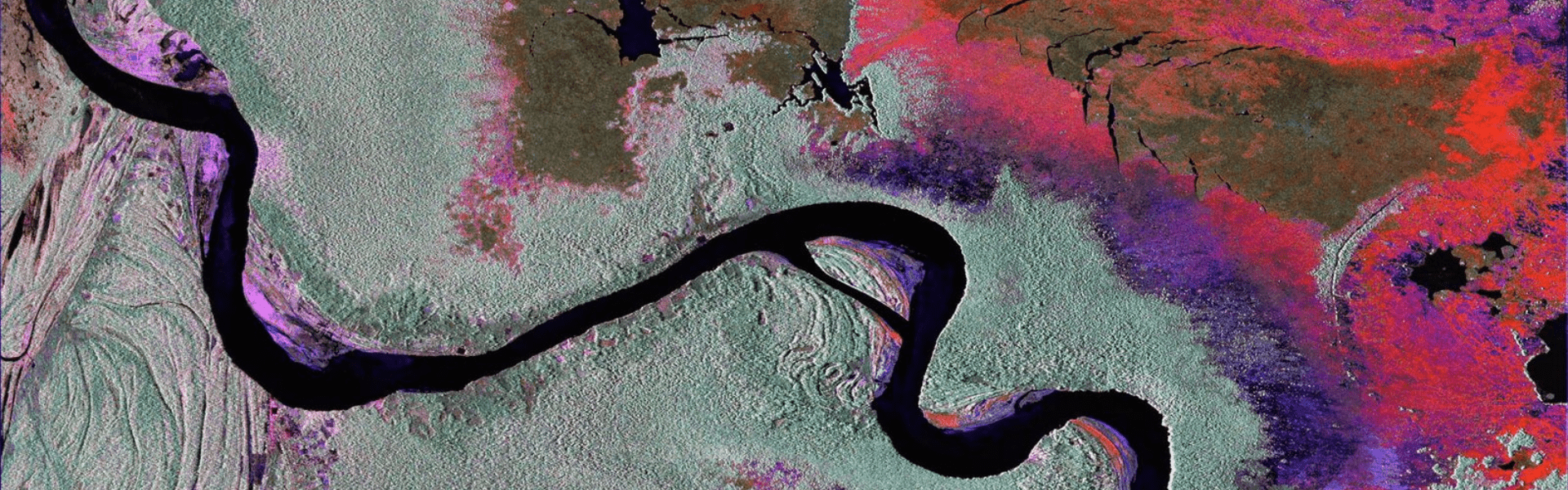
Quickly assess flood-affected areas with wide-area radar snapshots.
Flood Mapping & Post-Disaster Assessment
Use Cases:
Rapid post-cyclone flood extent mapping
Monitoring floodwaters near substations or water/sewer assets (utilities)
Impact validation for insurance, council or emergency services
Detection of lingering flood zones in inaccessible regions
Tracking changes in riverbanks or wetlands over time
SAR cuts through cloud cover to deliver flood maps even during bad weather — ideal for emergency responders and councils.


Gain near-real-time insight into flood extent and impact using satellite radar data that cuts through clouds, day or night. When every hour counts, radar satellites deliver flood maps fast — no drones, no flyovers, just immediate visibility into affected zones. Ideal for emergency response, asset protection, and post-disaster
Industries:
Local and state government, emergency services, civil and infrastructure engineering, utilities (water, energy, telecommunications), insurance, agriculture, and environmental and catchment management authorities.
More info:
Solution overview: Flood Damage Assessment
Use Case: Analysis of Heavy Flooding in Pakistan
Demo Video
Contact:
Email: contact@orbivis.com.au
© 2025. All rights reserved.
ABN: 23 021 187 233
Address: Sydney, Australia
Contact Us
Reach out to orbivis for geospatial solutions and data-driven decision-making support today.