Orbivis is an independent space and geospatial advisory practice supporting global organisations entering and operating in Australia. We specialise in space partnerships, on-ground representation, GEOINT, and strategic geospatial solutions that help space companies, Defence, government, and industry make informed decisions.
With expertise across market entry, business development, satellite data solutions, and space-based intelligence, Orbivis connects international innovation with Australia’s growing space ecosystem.
Explore how we support government, defence, and industry use cases
GEOINT & Maritime Domain Awareness (MDA) →
Persistent maritime intelligence for vessel tracking and dark ship detection.
Built for border security and operational awareness.....
Explore this capability →
Land & Infrastructure Disturbance Monitoring →
Millimetre-level ground movement detection from space.
Identify infrastructure risk before failure occurs.....
See how this is applied →
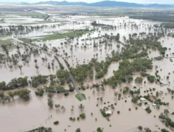
Flood Mapping & Post-Disaster Assessment →
Near real-time flood mapping from satellite radar.
Inform emergency response and post-disaster recovery…
View use cases →
🚀 Impressed by Japan’s Japan’s Space Domain Defense Guidelines set a clarity benchmark
Impressed by the conciseness of Japan’s newly released Space Domain Defense Guidelines — and the strong use of graphics to make complex concepts like SDA, resilient SATCOM, EO, and space protection easy to grasp.
🧑🚀 From Australia’s first astronaut trained under our own flag to new research partnerships,
#IAC2025 highlighted a nation on the rise in space capability — across PNT, EO analytics, SSA,
and access-to-space. Proud to help connect data, insight, and innovation to outcomes.
🛰️ Japan moves from owning satellites to buying outcomes
Japan’s Ministry of Defense is shifting toward constellation-based ISR delivered as a service — prioritising persistence, resilience, and faster decision cycles over episodic collection.
🐟 When “civilian” fleets behave like coordinated systems
New reporting highlights unusually large, coordinated fishing formations in the East China Sea — illustrating how scale and coordination can complicate maritime domain awareness and pattern-of-life analysis.